
Understanding the places we work in and the "crisis of representation."
There are three basic forms of representation that we use to understand a project and its context: aerial views (plans) that serve to locate and give it scale, ground level perspectives that serve to illustrate what it might feel like to inhabit that space, and models which are miniature versions that can be wholly viewed. At the same time, we need written narratives, films and photographs to describe or to assimilate into the social and cultural environment we are working in. To “know” a place it is necessary to be able to describe its physical attributes and to carry stories and memories of events that have taken place within its confines.
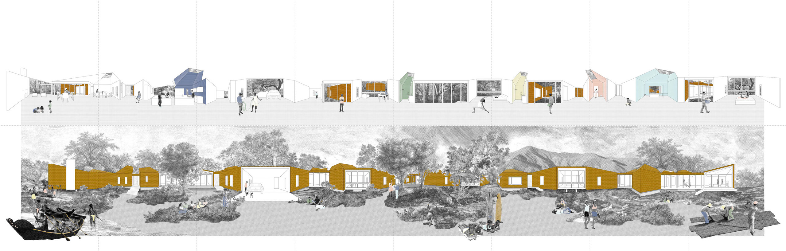
Narrative drawing of our Branch House in Montecito, California showing the building "unfolded" with a timeline of the peoples and cultures that inhabited the area.
In his book 'Invisible Cities,' Italo Calvino gives a fictional account of a young Marco Polo diverting the Emperor Kublai Khan with stories of the places he has visited during his travels. Eventually it becomes clear that each of the places Marco has described is actually different versions of the same city. In the end, he reveals the fiction to the emperor Marco telling him: “Every time I describe a city I am saying something about Venice.” Calvino's storytelling reminds us that the image of a place is different for every person that has lived or visited it. A difficulty compounded by the fact that each person carries multiple memories of a given place. While the mental map that Marco carries of Venice is rich and varied, it is also less real than the map of Venice that the emperor can see in his atlas. Here in lies the crux of the matter, while the memories we carry of a place allow us to feel connected to it, these memories are slippery and dissipate quickly. Physical plans may be just as incomplete, but they offer us the illusion of permanence.
Calvino, Italo. Invisible Cities. Harcourt Brace Jovanovich (May 3, 1978).
“I think you recognize cities better on the atlas than when you visit them in person," the emperor says to Marco snapping the volume shut. And Polo answers, "Traveling, you realize that differences are lost: each city takes to resembling all cities, places exchange their form, order, distances, a shapeless dust cloud invades the continents. Your atlas preserves the differences intact: that assortment of qualities which are like the letters in a name” (Calvino, 'Invisible Cities').
As architects, we use plans and other drawings to try to determine certain qualities of a place: zoning, topography, and boundaries of a site. On the other hand, we also try to understand the stories of a place. Memories we formed while visiting the site and talking to the people that live there. When doing research on a particular community in Los Angeles for example, we are able to designate a planning typology by simply recognizing the hierarchies of the streets and the shape of cul-de-sacs on a map. However, without knowing more about the social, demographic and cultural environment on the ground, we can only use this categorization to describe a set of geographic relationships or historical constructions. To truly understand a neighborhood, we also need to know something about the community's social makeup and its cultural character.
To understand place one must understand the whole and the complex interactions between all of its parts: infrastructures, buildings, and peoples. In addition, one must understand how each of these has changed over time. When Rayner Banham took on Los Angeles as an object of study he was interested in exploring the city’s continuous adjustments in the apportionment of land and resources. He saw the city not as a static place, but as a place that undergoes constant mutation and transformation. The transformations may have been caused by internal changes (economic investment, financial downturns, immigration policies, laws, education, gentrification) or by external pressures (wars, migration treaties, economic setbacks in neighboring countries.)
Banham, Reyner. Los Angeles, The Architecture of Four Ecologies. New York: Harper and Row, 1971.
Historically, architects and urban designers have relied on top-down approaches, looking for overall patterns to make a place legible. The reliance on making plans based on empirical data and geographic relationships, while still widely used, has its downsides. Our argument is not that plans are not useful, but that to quote the landscape architect James Corner, this “present[s] only one version of the earth’s surface, an eidetic fiction constructed by factual information.” Known as “the crisis of representation” this idea was a cornerstone of postmodern critique, which questioned the validity of plans as a tool to understand the world given that they are always tainted by power hierarchies. We can meet this “crisis of representation” with despair, throwing up our hands to say “what is the point of moving forward if nothing we do can ever be true or just,” or we can accept that the drawings and models we make provide only a partial view and move forward. Utilizing standard representations along with stories and speculations has allowed us to develop responses to the built environment that are elastic and that engender new sets of possibilities.